
| After the expeditions of Abel Tasman
(1642 & 1644) there was little Dutch activity relating to
the South Land. This lasted until 1694 when the East Indiaman Ridderschap
van Holland was lost. It was assumed to have been shipwrecked in
the Southland since some maintained that this country lay further
to the west than indicated by the charts. Again the VOC had a reason
to explore and survey the dangerous coasts of Australia.
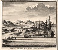
Willem de Vlamingh, an experienced VOC officer, was appointed to search for signs of the wrecks and possible survivors from the Ridderschap van Holland and the Vergulde Draeck, which was lost in 1656. They were also to find new staging places between the Netherlands and the Cape of Good Hope, and from the Cape to Java. For this reason de Vlamingh’s route included the islands of Tristan da Cunha, Amsterdam and St Paul. For this expedition the VOC directors decided to build a new fleet, the hooker Nijptangh, the galliot ‘t Weseltje and the frigate Geelvinck. With its shallow draft ‘t Weseltje would prove very useful for exploring close to the coast.
‘God in heaven be thanked for our safe voyage’. Willem de Vlamingh in Günter Schilder, Voyage to the Great South Land …(1985)
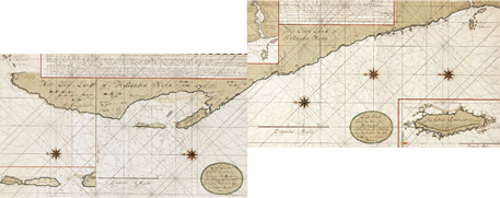
Two manuscript charts of the west coast of ’t
Land van de Eendracht Gerard van Keulen, 1678-1726 This manuscript chart of the west coast of Australia was identified by Günter Schilder in 1981 as the work of Gerard van Keulen. It is based on the information gathered during the Willem de Vlamingh expedition in 1697. Victor Victorszoon, was commissioned by the VOC to make a manuscript map from the maps produced by de Vlamingh. Gerard van Keulen must have copied the information from the original manuscript map of 1697: all the details are identical, only the layout is different. Joannes van Keulen included a printed version of his father’s chart in his six-volume atlas, Nieuwe Groote Lichtende Zee-Fakkel (New Great Shining Sea Torch) of 1753. These charts remained with the van Keulen firm until 1875 when the firm was liquidated. The London based collector Edward Augustus Petherick acquired the charts and displayed them in 1895. They were acquired by the National Library of Australia as part of the Petherick collection in 1911. It is only in the last few years that these charts are now thought to be the original charts drawn by Gerard van Keulen and not by Isaac de Graaff another VOC cartographer. Only three sheets of the van Keulen manuscripts documented are of the Australian coastline. The two held by the Library and the third by Nationaal Archief, the Hague in The Netherlands. On loan courtesy of the National Library of Australia, Canberra: RM 751 and 752. Formerly collection E.A. Petherick. |