This warning, however, did not prevent the loss of two Dutch East India Company ships in the Houtman Abrolhos some years later — Batavia in 1629 and Zeewijk in 1727. In their letters home, de Houtman and Dedel’s mention of gold made their masters extremely interested in the new land and keen to investigate futher. Although the VOC took every measure to keep the sailing routes secret, competitors inevitably got to know about them. In 1622 the English East India Company ship Trial tried to follow the new south route but the voyage ended in catastrophe off the Monte Bello Islands. ‘This Southland, it seems to be fine country as we could see…’ ‘…one should stay clear of this shoal, for it
lies most treacherously for ships that want to call in at this
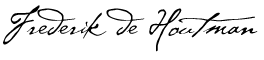
land. It is at least 10 mijlen long; lies at 28 degress, 26 minutes.’ 'The Land of Eendracht looked to be red, clayish land, and, according to some people’s description, could be found to be rich in gold…’ Jacob Dedel
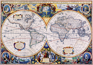
Hendrik Hondius Hondius’ twin globe map of the world, with its elaborately drawn margins and portraits of Mercator, Caesar, Ptolemy and Jodocus Hondius in the corners, is the first dated map in an atlas to show any part of Australia. Charted are the 1623 discoveries of Dutchman Jan Carstensz on the west coast of Cape York Peninsula. For first time on a widely available printed world map, the early Dutch discoveries of Australia are shown. This map is a watershed in the history of the mapping of Australia. Hondius lists place names on Australia’s west coast indicative of the discoveries of Hartog and de Houtman including Dirk Hartog's ree and T. Lant van Eendracht, F Houtmans arbrooleus and Dedelis landt. On loan from Jock Clough Collection |