
Location
of the wreck
Dampier also did not state where the events that led to the loss
of his ship took place and a long-standing island ‘tradition’
had
it that his vessel lay in South West Bay. As one example, an
account appearing in J.E. Packer’s The Ascension Handbook:
A concise guide to Ascension Island (1968) reads thus:
1701—Wm. Dampier’s vessel ‘Roebuck’ wrecked
probably near S.W. Bay.
This
belief that the wreck lay in South West
Bay apparently was partly the result of the location of two
ancient anchors there (Packer, 1968). It is also reflected in
the exhibitions at the Island’s Museum as these also referred
to South West Bay as the most likely site.
Further, in a short précis entitled Wrecks Around Ascension
Island that was produced in 1993, author Jeff Cant, also
comments that ‘South West Bay seems to be the most
popular choice for the beaching’. In presuming that, as
Dampier fails to mention the ship after it was beached,
Cant was of the opinion that Roebuck most likely ‘broke
up due to the action of the seas’ (Cant, 1993).
Part of the reasoning behind the ‘South West Bay’
hypotheses also appears to be deductions based on the
naming of a freshwater spring on the north-west side of
Green Mountain on Ascension Island ‘Dampier’s Drip’.
Because Dampier recorded he had to travel over a high
mountain to access a spring, this led many to concluded
that the wreck lay somewhere other than in bays on the
north-west side of the island.
A reading of Dampier’s own account above indicates that
the name given to the spring on the north-west face of
Green Mountain was in error, however.
In examining Dampier’s own accounts and in plotting the
positions he gives for his vessel it becomes apparent that
of all the potential places on the Island, only Clarence Bay
on the north-west side fits the bearings he recorded as he
came to anchor in a sinking condition.
…at
nine aclock in the morning anchored in the
N.W. bay in ten fathom and half water, sandy
ground about half a mile from the shoare, the
S. point of the bay bore S.S.W. dist. one mile
and a half and the northernmost point, N.E.
1/2 N.dist. two mile…
Testimonies provided at the subsequent court martial
into
the loss of HM ship Roebuck and the logs of the vessels
that rescued Dampier and his men all lead the researcher
to focus the north-west side of the island. The following
précis from David Hepper's 'British Warship losses in the
Age of Sail' is but one indication that many others had
previously followed this same line of reasoning.
1701,
24 February 1701 Roebuck 5th Rate 24 guns
292 tons.
Wapping 1690, Capt. William Dampier
Returning to England after a voyage of exploration to
Australia and New Guinea, a bad leak was discovered
in the larboard bow as she approached Ascension Island.
The Roebuck anchored in the north-west bay of the island,
while efforts were made to stop the leak, but a plank
about four strakes up from the keel was found to be
completely rotten. Filling with water, she was deliberately
run close inshore until she grounded, to allow the crew to
land before she foundered. The crew spent some time on
the island before they attracted the attention of a passing
East Indiaman to take them off the island. Dampier was
later court-martialled for his actions on board the Roebuck,
which had led to a mutiny when in the Far East. He was
subsequently ordered to forfeit all pay due for the voyage
and not employed again. (Hepper, 1994:21)
Further considerations in developing the Western Australian
Maritime Museum’s search strategy were the methods and
equipment utilised by the Joint Services team that
performed an extensive search in 1985. While also believing
that the site most likely lay in Clarence Bay, in The Long
Beach area, they also examined South West Bay and
English Bay in their search for the ship (see following).
Earlier searches - top
Robert Marx’s visit in 1973
Robert Marx, a noted wreck hunter, recently indicated that
he had found the site in 1973. In a letter on that subject
he stated that:
Dampier left such a vivid
and accurate account
of the area in which his ship was lost, that I was
able to find it in less than 20 minutes of diving.
With the assistance of several amateur divers
from the missile tracking base, we recovered
a large number of interesting artefacts which
we donated to the local museum.
This claim came as quite a suprise when it was received
in
August 2001, six months after the Museum’s team returned
from Ascension Island, given the continuing conjecture on
the island as to the whereabouts of Roebuck that existed
right through to March 2001 amongst service personnel,
amateur historians and museum officials on the island itself.
The claim, which is considered to relate to a nearby wreck,
but not Roebuck, is dealt with at length in the Museum’s
report on the expedition.
The 1979 Search
Commander John Bingeman, then a serving Royal Navy officer,
had also conducted an extensive search for wrecks off the
west coast and around English Bay. His primary focus was
the location of HM Ship Roebuck and his team initially
searched South West Bay, Roebuck’s 'traditional' resting place.
Commander
Bingeman advised that these searches were
conducted utilising a towed diver system from an inflatable
boat and he indicated that his ‘servicemen considered
they were being used as shark bait’ in the process! In
being unsuccessful, and in reassessing Dampier’s log,
Bingeman shifted his focus to North West Bay (Clarence
Bay) off Long Beach and concluded that the wreck lay
buried in the sands off the centre of Long Beach. Despite
many hours of towed searches the team failed to find
any trace of Roebuck.
Commander Bingeman also conducted an extensive
archival study and inspection of three wrecks in the
area Normandie (1900), HM Store Ship Maeander (1870)
and a site in Powerhouse Bay that appear to be a
conglomeration of HM Store Ship Tortoise (c. 1859)
and the Soudan (1892). (Bingeman to McCarthy,
14/10/2001). His work appears to have provided the
groundwork for the 1985 search, following.
The
1985 Search
The RAF combined Services team utilised swim searches
on scuba and diver tow systems on snorkel and they
searched widely and performed a very important function
in examining and reporting on all other wrecks on the
island. They also recorded that two large anchors had
earlier been recovered from North West Bay, though
their provenance and location was not known.
Squadron Leader C.R, Tebbs RAF, the expedition leader
and compiler of the team’s report, concluded thus:
In part, the archaeological
aims of the expedition were
achieved, except in the unsuccessful search for the Roebuck.
Owing to the highly magnetic nature of the volcanic rock
and the serious interference from all the communications
equipment and satellite aerials situated on the island,
the full potential of the magnetometers was not achieved.
However, the magnetometers were used successfully
in locating the wreck sites of the iron ships and the task
of locating these areas would otherwise have been
much more difficult.
Extensive searches were made in the seas off Georgetown
(the capital of ASI) and southwards to South West Bay.
Underwater sleds were used to good effect in carrying
out the required search patterns.
He
then concluded that the wreck most likely was to be
found off Long Beach! (see following).
Problems in fixing a search starting point
- top
Apart from conducting the literature searches referred to
above, the author and M Philippe Godard also conducted
an analysis of the primary sources obtained by researcher
Hannah Cunliffe of Wiltshire.
She was commissioned to
obtain copies of all Dampier-related materials held in British
archives, including depositions at the courts-martial into
the loss of Roebuck.
These documents were closely examined and the resultant
analyses were produced as a Museum report aiming to fix
the most likely search area before departure
(McCarthy and Godard, 2001).

M Philippe Godard
By this means North West Bay became the focus of attention,
tallying with our Ascension Island liaison officer Flt Lt
Richard Burke’s belief that the wreck was most likely in
those waters.
An analysis of the primary documentary evidence, a
précis of which appears in the Museum’s report, shows
that after first anchoring his vessel in 10 fathoms of water
off North West Bay and concluding that he could not save
Roebuck, Dampier would have had some time to consider
his options before driving the vessel towards the shore,
where as the breeze dropped, he again anchored.
After sending an anchor ashore, he hauled the vessel in
further until it came to rest in three and a half fathoms
(7 metres deep) of water a cable’s length (c. 200 metres)
from beach. The evidence contained in his depositions to
the Court when read carefully against those of the others
who also did so, e.g. the Master, indicate that the wreck
lay in water no more than three and a half fathoms
(7 metres deep) off Long Beach.
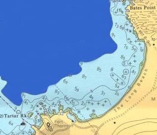
Clarence Bay area and Long Beach -
top
Confounding the matter and making what appeared to
be an apparently straightforward conclusion problematic,
was the fact that none of the vessels that came into what
they called ‘Ascension Roads’ in April 1701 and anchored
‘close to’ in Clarence Bay, saw the wreck. These were
the 350 ton East India ship Canterbury and HM Ships,
the 620 ton Anglesey, the 384 ton Hasting and the 6th
rate Lizard.
The
wreck should have been visible not much more than
a few cable’s length away towards the shore (a distance
of c. 500 metres). Instead the three ships noticed
Dampier’s men first, an apparent indicator that the wreck
was then totally submerged, having broken up, was lying
on its side, or equally that it was lying somewhere
out of their view, possibly even against a backdrop
of cliffs at the northern or southern ends of the beach.
Perhaps it had broken up and was now engulfed in the
sands of the beach itself (as is quite often the case
elsewhere) for this particular beach was apparently quite
mobile. Squadron Leader Tebbs had come to this
conclusion and he wrote in the account of the 1985 RAF
searches that:
It
seems most likely that the Roebuck lies underneath
the deep sands of Long Beach at Georgetown, and the
wreck will probably only be located either after a heavy
storm that may shift the sand, or by the use of side-scan
sonar or other sub-surface search equipment.
Alternatively it had drifted back out to sea, and again
compounding the problem were Dampier’s own accounts.
One, appearing in the preface to the 1939 edition
of his Voyage to New Holland reads
‘…my Ship, having sprung a Leak
which
could not be stopped, foundred at Sea; with much
difficulty we got ashore’
(Williamson, 1939: xxii).
In that same edition appears a letter from Dampier to
the Earl of Pembroke, President of the Privy Council.
It reads thus:
The
World is apt to judge of every thing by the Success;
and whoever has ill Fortune will hardly be allow’d a good
Name. This, my Lord, was my unhappiness in my late
Expedition in the Roe-buck, which founder’d thro’
perfect Age near the Island of Ascension.
The trusim in the opening sentence is ages old!
The use of the phrases ‘foundred at Sea’ and ‘founder’d
…near the Island’ lead one to the conclusion that though
it had been warped ashore at Clarence Bay, there was
a distinct probability that HM Ship Roebuck may have
finished up in deeper water off the Island. This could
only have occurred if the cable holding the wreck to the
shore parted and it could have had drifted back out
to sea with the prevailing winds as a semi-submerged
derelict.
In planning for the Museum’s first visit, it was decided
to opt for the first model, i.e. to base the search on the
assumption that the ship had not drifted back out
to sea and that its remains still lay near the position at
which the ship was abandoned . It was realised that the
first task was to follow Dampier’s recorded movements as
his ship slowly sank beneath him by fixing his compass
bearings and anchoring where and as he described the
event in 1701. Then, if these still supported the notion
that the ship was run ashore at Long Beach, rather
than South West Bay or any other locality, to rigidly focus
the search in shallow water a maximum of 200 metres
from the present shore at Long Beach in Clarence Bay.
In accepting that the beach may have subsequently
covered the ship, or that it lay buried under sediments
offshore, a combination of visual and remote sensing
searches (magnetometers) were planned and minimal-
disturbance water-powered sand probes were proposed
as a first stage in what was expected to be a prolonged
campaign, taking a number of seasons.
If results indicated that the vessel was not in shallow
water or under the beach, a deep-water search using
visual and remote sensing methods (e.g. magnetometer
and side scan sonar systems) would need be conducted in
later years.
Neil MacFall’s analysis - top
Finally, in conducting a www search under the headings
‘William Dampier, Roebuck and Ascension Island’, an
analysis by Ascension Island resident and researcher
Mr Neil MacFall was found in electronic copies of the
Islander for the year 2000. In noting the impending
arrival of the Western Australian Maritime Museum’s team,
he wrote under the heading ‘Where is Roebuck’ as follows.
.
… tradition
says that it was wrecked near South West Bay
and that the crew survived on the Island by following a
goat to a supply of water at the place that is now called
Dampier's Drip…In fact this log of Dampier's will bear closer
inspection because if it is read carefully it will reveal that
the "Roebuck" is very unlikely to be found off South West
Bay at all. With a diving party expected on the Island to
search for the wreck I thought it might be a good time to
open a discussion on where the ship may now lie and
therefore offer my theory to (hopefully) open this forum.
…
The area around South West Bay would not offer a safe
or even convenient anchorage. Dampier's log for 23
February 1701 states:-
"at 9 anchored in 10 and a half Fathom, sandy Ground.
The South-point bore South-South-West distance 2
Miles, and the North-point of the Bay, North-east
half North, distance 2 Miles"
The sighting of a point of land two miles to the southwest
straightaway rules out South West Bay. The only area
where this could apply would be on the north eastern
side of the island between Bottle Point and North West Point -
or in "English Roads". The second point of the description
"2 Miles to the North-east, half North" could apply to anywhere
on the south coast or the west coast from South East Bay
to "English Roads".
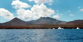
Clarence Bay and Green Mountain from the sea
- top
Therefore
the only place to fit both descriptions would
be "English Roads" or as we call it Clarence Bay.
Neil MacFall used this research as the basis of the design for
an issue of Ascension Island stamps commemorating the
Tri-Centennial of the arrival of Dampier in February of 2001.
Presented to the Museum team on arrival at Ascension Island
the next month, the stamps carried a depiction of events
that was later to prove to be remarkably accurate.
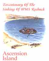
Artwork, produced under instruction
from the Administrator and Neil MacFall
for the Dampier Tricentenary stamp issue,
showing
his
analysis of the location of
the wreck.
Go to Daybook!