Researchers' Diaries
Clay Bryce
Molluscs and Cruise Leader, Dept Aquatic Zoology, Western Australian Museum
Clay Bryce: Molluscs and Cruise Leader, Dept Aquatic Zoology
The WA Museum's Kimberley project has two main parts. The first component relates to historic data, which is housed within the vast collections of the Western Australian and other Australian museums. The second part relates to the more recent or contemporary data collected during recent fieldwork in October of 2009 and again later this year in 2010; and also field data collected from targeted surveys undertaken in 2006 off the NW Atolls (Mermaid Reef (Rowley Shoals), Scott and Seringapatam reefs). The results from the NW Atolls survey have now been published and can be found on the “Publications” page of this website.
The WA Museum's Kimberley project involves several museums from around Australia (see the team page) pooling their accumulated knowledge (historic datasets) to provide a snapshot of what marine animals live in the Kimberley and also where they live.
- Photo by Clay Bryce
- Copyright Western Australian Museum
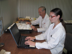
Here at the WA Museum the historic datasets for the project have being worked on by the project's two intrepid database people, Albert Miles and Stacey Osborne since late 2008
Together, they have databased nearly 19,000 specimen lots and this work will continue through to 2011. The historic collections and old report data is difficult to deal with as it has been collected over many years by many different researchers during separate collecting trips and expeditions using different collecting methods. Therefore, what we expect to get from the analyses of these data is a “big picture view” of what marine life is found where. In contrast, the contemporary data will be more targeted and allow direct, fine scale analyses of the marine life and habitats from the southern Kimberley region (Adele Island and Montgomery Reef undertaken in 2009) and from the northern Kimberley (presently being planned for Cassini Island and Long Reef in 2010).
Planning for the field component (contemporary data collection) started around February 2009 for the expedition in October 2009. The logistics for such a trip are huge. Planning involved the what and the how of the science (our methods), where and when we would do the work balanced against tide times and dive times, what experts to take and the best weather window, a big enough vessel needed to be booked to accommodate us and our gear, lists made of gear we would require, airfares booked and all the occupational, health and safety issues had to be considered – such as tides, crocs, sharks, shipboard safety, dive safety etc! So much to do – reams of paper, meetings and endless lists seemed to dominate!
By a tender process, the charter vessel, Kimberley Quest was chosen and booked for both the 2009 and 2010 trips to match desired tides in October of each year. The timing of the expedition is always a compromise of best tides, ship availability, weather conditions and when people can come – quite a headache! Fourteen people were selected to represent their particular fields of expertise and these are listed below.
Field Participants
|
Clay Bryce (WAM) |
Molluscs / Cruise leader/ dive supervisor |
|
Peter Morrison (SKM) |
Video habitat mapping |
|
Sue Morrison (WAM) |
Fishes |
|
Jeff Johnson (QM) |
Fishes |
|
Alison Sampey (WAM) |
Echinoderms |
|
Lexie Walker (AM) |
Polychaetes |
|
Monika Schlacher (QM) |
Soft Corals |
|
Rainbo Dixon (HWA) |
Marine Flora |
|
Lee Betteridge (WAM) |
Crustaceans + general help |
|
Corey Whisson (WAM) |
Molluscs |
|
Andrew Hosie (WAM) |
Crustacea |
|
Zoe Richards (JCU) |
Corals |
|
Corioli Souter (WAM) |
Maritime Archaeology |
|
Jim Stedman (WAM) |
Maritime Archaeology |
WAM = Western Australian Museum, QM = Queensland Museum. AM= Australian Museum, HWA = Herbarium Western Australia (DEC), JCU = James Cook University, SKM = Sinclair, Knight, Mertz
A mountain of gear was assembled. This included 14 SCUBA kits, wet suits, clip boards, dozens of pencils, reef walking shoes, litres of sunscreen, several fish nets, chisels, hammers, cutting boards, GPS units, thousands of plastic vials, jars and other assorted containers, thousands of zip lock plastic bags and heavy duty plastic bags, hundreds of litres of chemicals, 30 transport drums, 30 buckets, 5kg of silica gel, microscopes, cameras, a drying oven, fans and the list went on and on. All to be loaded onto the Kimberley Quest – I was concerned there might not be room for us!
Needless to say we all arrived on time, boarded the boat and some 24 hours later were ready to dive at our first sampling station off Adele Island on the 13th October, 2009.
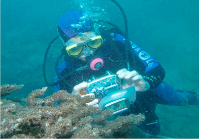
- Station 5: Dive at sub-littoral channel slope. Dr. Monika Schlacher investigating Kimberley soft corals for the first time (Adele I.)
- Photo by Clay Bryce
- Copyright Western Australian Museum
Survey Locations:
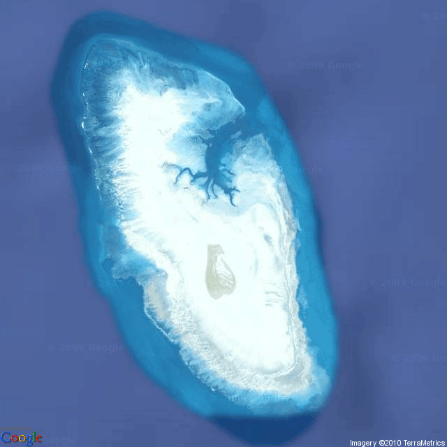
Adele Island: this remote southern Kimberley Island has never been formally surveyed for its marine biodiversity.
The WA Museum visited the island very briefly for a single visit in 1983 and made a small collection of marine fauna at 2 stations. The island was the subject of a geographical survey in 1948 as part of a review of the coral reefs of the Sahul Shelf by Curt Teichert and R. W. Fairbridge. Their results were published in the Geographic Review by the American Geographical Society of New York. Their work outlines the perceived geomorphic zones of the reefs and islands from World War 2 aerial imagery.
Our museum survey is the first formal biodiversity survey undertaken at the island. We worked around the island between the dates of 13-18 October, 2009 and a total of 13 stations were sampled by the 12 participants using either SCUBA ping or intertidal walks. Each station was sampled for one hour by each participant achieving 12 hours of effort per station for each of the 8 taxonomic groups. At each station a three transects were laid and videoed for later interpretation and analysis. These replicated transects were surveyed by the participants and the plants and animals recorded. This process allowed us to count the numbers of organisms of each species in a defined area on the reef and provide abundance data for further analyses.
The main geomorphic units sampled from seaward to shoreline were:
- Front reef slope down to 20 m depth – i.e. from the intertidal reef crest the reef slopes down into the ocean.
- Reef crest - at low tide where the ocean meets the intertidal reef edge.
- Back Reef - the back edge (lagoon or island side) of the intertidal reef platform.
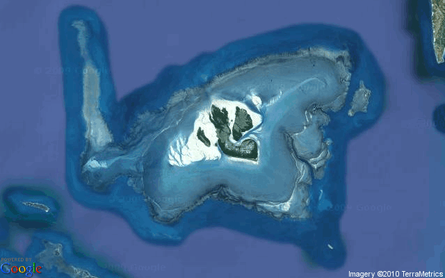
-
- Adele Island
- Copyright Google Maps
Montgomery Reef: This is a huge reef covering 300sq km of reef platform. The WA Museum has visited this reef three times in the last 20 years but only for very short periods where limited opportunistic collections were made. This 2009 survey is the first formal and comprehensive biodiversity survey undertaken at this reef.
We left Adele and worked Montgomery Reef between the dates of 19-24 October, 2009 and a total of 14 intertidal stations were sampled by the 12 participants using intertidal walks. Because of crocodiles, dirty water and very strong currents SCUBA ping was not a safe option. Like Adele Island, each station was sampled for one hour by each participant achieving 12 hours of effort per station for each of the taxonomic groups. Videoing of the transects was also undertaken. At each station a three transects were laid and videoed for later interpretation and analysis. These replicated transects were surveyed by the participants and the plants and animals recorded. This process allowed us to count the numbers of organisms of each species in a defined area on the reef and provide abundance data for further analyses, including transect videoing. The main geomorphic units sampled were:
- Fore-reef ramp – sloping outer intertidal reef “ramp” leading downwards to the water level at low tide.
- Fore-reef terrace – flattened intertidal reef platform extending from the fore-reef ramp back to a sand, rubble and Rhodolith barrier.
- Upper-reef terrace – stretches inshore from the fore-reef terrace barrier to the mangrove fringed islands and sand bars. This upper-reef terrace structure should perhaps be considered to be a wide, shallow lagoon.
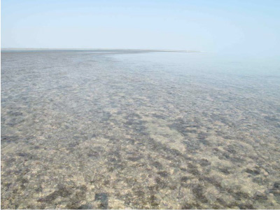
-
- Station 22: Montgomery Reef. Rhodolith sand and rubble lagoonal barrier (116m wide). The lagoon is to the right and the barrier to left of image with a distant fore-reef slope displayed in the upper left of the image.
- Photo by Clay Bryce
- Copyright Western Australian Museum
-
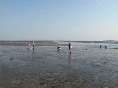
- Station 21: Intertidal, mid-littoral fore-reef ramp in channel. Researchers working along the replicated transects used at each station.
- Photo by Clay Bryce
- Copyright Western Australian Museum
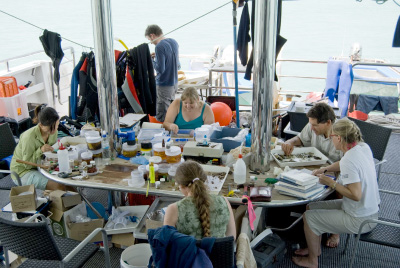
- Processing between collecting stations - this was also happening on the upper deck and in the saloon
- Photo by Clay Bryce
- Copyright Western Australian Museum
- Montgomery Reef
- Google Maps
The Last Word: Needless to say a lot of science was done with 12 biological researchers working at each station – that's 12 researcher hours per station! Twenty seven stations were completed giving 324 researcher hours spent surveying the reefs. The field samples and associated data will take some 12 months to examine and analyse before the write up can begin and then, in some cases, depending on the marine faunal group, this information will be added to information from the next trip before a final assessment and write-up can be completed.
It is pleasing to report that we all came back alive without a single accident – or crocodile encounter!

Read the diaries of the other scientists on the expedition:
Dr Monika Schlacher
Marine Zoologist, Sessile Marine Invertebrate Section, Queensland Museum

Clay Bryce
Molluscs and Cruise Leader, Dept Aquatic Zoology, Western Australian Museum

Alison Sampey
Research Officer, Department Aquatic Zoology, Western Australian Museum

Lee Betterridge
Technical Officer, Crustacean Section, Aquatic Zoology, Western Australian Museum

Corioli Souter (Curator) and Jim Stedman (Assistant Curator)
Corioli Souter: Curator, Maritime Archaeology, Western Australian Museum Jim Stedman: Assistant Curator, Maritime Archaeology, Western Australian Museum

Corey Whisson
Mollusc Section, Aquatic Zoology, Western Australian Museum

Sue Morrison
Acting Curator, Fish Section, Aquatic Zoology, Western Australian Museum

Lexie Walker
PhD student (Polychaetes) of Australian Museum

Rainbo Dixon
Marine flora, Murdoch University

Andrew Hosie
Curator of Crustacea, Aquatic Zoology, Western Australian Museum

Zoe Richards
Marine and Tropical Biology, James Cook University
