
• The Baudin Expedition • French maps of Australia • Australian flora and fauna presented in France
Early French interest
in the southland
The roots of the voyage of the French corvette L’Uranie
in 1817-1820 date back to Paulmier de Gonneville in
1504. He thought, after experiencing a violent storm
near the Cape of Good Hope, that he had chanced
on the fabled Terra Australis Incognita, a vast southern
land mass long postulated as a necessary balance to
the continents in the northern hemisphere. Thereafter
called ‘Gonneville Land’ by the French, it became a
focus for their maritime aspirations in the region and in
1738 Bouvet de Lozier set out in search of it but found
only the barren island that now bears his name.
By then the Dutch, notably Dirk Hartog (1616), Carstensz
(1623), Thijssen (1627), Abel Tasman (1642 & 1644)
and Willem de Vlamingh (1697) had landed and charted
much of the north, west and south coasts of what
afterwards became known as New Holland. William
Dampier also had a hand in the exploration of New
Holland and he records landing on the north west coast
in 1688/1699. Though following the Dutch in dismissing the
land and its inhabitants in a hugely popular and widely
disseminated account—and thereby fixing the negative
attitudes that were to remain commonly held for another
century—he and his colleagues were the first Britons
to land there.

A French chart of New Holland circa 1850.
The loss of territory to the British on the north American
continent in the late 1750s caused the French to actively
look elsewhere for colonies. In 1763 Louis Antoine de
Bougainville, who had fought against the British in Canada
and who was the first Frenchman to sail around the world,
established a small colony at Port Louis on what he called
the Iles Malouines in honour of the predominantly St Malo
element amongst his colonists.
The British countered this in 1764 by sending Commodore
John Byron who arrived early in the following year, took
possession of them as the Falkland Islands.
In 1767 France ceded its rights to Spain, commencing a
| chain of events that has led to Argentina claiming the
islands as Las Islas Malvinas.
It was a disagreement that has had repercussions well
into the modern day, and is one that also had ramifications
for the Uranie voyage and for the survival of its castaways.
In commenting on his visit to the area in 1820, the Antarctic
explorer James Weddell stated that the colonists were
an …industrious
and enterprising people, after having made
considerable progress in fertilising the ground, were displaced
by the Spaniards, who claimed the islands.
They, however, partly through political motives…neglected
the improvement of the country, and latterly entirely
abandoned it (Weddell, 1827:94)
Continuing what in effect was a ‘superpower’ race for
territory, in 1766 the British navy sent two ships under
Wallis and Carteret to the south Pacific in search of the
fabled southern continent, and the French despatched
Bougainville with the same intention just three months
later.
While the French and the British found many islands in
the Pacific, including Tahiti and Pitcairn, neither found
the southern continent.
The closest Bougainville came to Terra Australis was
when he encountered the Great Barrier Reef adjacent
to present-day Cooktown in far north Queensland.
On his return home in 1769 Bougainville published an
account entitled A Voyage Round The World, that
increased French interest in the Pacific.
In the interim James Cook departed on a scientific voyage
with secret instructions to explore the south Pacific.
In completing his first exploration in the period 1768-1771,
Cook called at Tahiti, circumnavigated New Zealand and
then travelled along a vast land mass he claimed for Britain
and named New South Wales. His proclamation was effected
with little reference, as was the fashion throughout the world
in those times, for the indigenous peoples and their rights.
This left unexplored the eastern part of the south coast,
lying between New Holland and Cook’s New South Wales,
and there existed a belief that a vast strait passed between
New Holland and New South Wales. (Scott, 1914:53).
The annexation of New Holland for France.
In 1771, two expeditions left Ile de France for the Indian
Ocean in search of Gonneville’s Land. One, led by Marion
Dufresne, sailed to Van Diemen’s Land (Tasmania) and
as far as New Zealand, alerting France to their worth though
as the names suggest both had been earlier discovered
by the Dutch, in this case by Abel Tasman.
The other, a two-ship expedition was led by Y.J. de
Kerguelen and it included as second in command, François
de Saint Aloüarn The ships separated and Kerguelen,
upon discovering what he thought to be Gonneville’s Land,
hurried home to announce the discovery of what he called
France Australe. Later, it proved to be a barren island that
now bears his name. In the meantime St Aloüarn in Le Gros
Ventre continued the search for Gonneville’s Land.
Unsuccessful, he then made for the coast of New Holland,
and in landing on Dirk Hartog Island at Dampier’s Shark Bay,
Saint Aloüarn annexed the coast for France in March 1772,
Godard and de Kerros, 2002; Marchant, 1998, McCarthy,
1998).
The La Pérouse and d’Entrecasteaux Expeditions
The young Napoleon Bonaparte applied for a place on the
next French expedition to the region under the command
of J.F. Galaup, comte de la Pérouse, but was lucky to be
refused. The best equipped of all scientific forays, this
two-ship expedition left French shores with a large contingent
of scientists and naval personnel in 1785. After extensive
explorations in the Pacific, they were ordered from
Kamchatka to Botany Bay in New South South Wales in
order to observe the British landing there in 1788 (Wood,
1922:507).
After doing so they departed for further work in the South
Seas and were never seen again.
In this same period William Bligh was in these waters with
HMS Bounty, following on from Dampier’s earlier revelations
about the efficacies of breadfruit. After the infamous mutiny,
Bligh was not to know that the Australian first fleet had
landed successfully under the curious eyes of the French,
and navigated in an open boat across the top of the
continent to Timor and safety.
In September 1791 another well-equipped French
expedition was sent under the command of J.A.Bruni
d’Entrecasteux with Le Recherche and L’Espérance to
continue the exploration and to search for La Pérouse.
Amongst the complement were scientists, botanists, a
gardener and hydrographers. On the south coast of
New Holland, they took many natural science specimens,
charted great skill and named many features.
While
they were to continue to give generally adverse
accounts of New Holland, at Tasmania their descriptions
of the land and people were to provide some relief to
the predominantly negative reports of previous explorers.
There d’Entrecasteaux observed that the tribe they
encountered
…seems
to offer the most perfect image of pristine society, in
which men have not yet been stirred by passions, or corrupted
by the vices caused by civilization…Oh! How much would those
civilized people who boast about the extent of their knowledge,
learn from this school of nature
(Duyker & Duyker, 2001 :xxxviii).
Their visit followed that of George Vancouver, who left
Plymouth in April 1791 for the north Pacific via the Indian
Ocean and the south Pacific. He landed at, and named
King George the Third Sound (Albany), then travelled for
a short distance along the southern coast before being
forced off it by bad weather.
In 1793 the d’Entrecasteaux expedition landed in the
East Indies on its way home to news of the execution of
King Louis XVI and a state of war between the new
Republic and much of Europe. By then both commanders,
d’Entrecasteaux, and his second-in-command, Huon de
Kermadec, and many others had perished through illness.
To make matters worse, the republicans on board were
denounced by their shipmates, imprisoned by the Dutch,
and both ships were sold to defray expenses. After being
confiscated by the British, the extensive natural science
collections, maps and charts eventually found their way
back to France where the botanist J.J.H. de Labillardière’s
Relation du Voyage à la Recherche de La Pérouse was
published in 1799, going through three English editions
and two German by 1804.
Containing 265 black and white illustrations together
with 13 plates by the renowned botanical artist P.J.
Redouté, it was the first illustrated work after Dampier’s
account of his voyage to New Holland in 1699 to
capture the imagination of the Europeans in respect
of the flora and fauna of the Southland. The expedition’s
hydrographer Beautemps-Beaupré then published his
atlas in 1807 and his cartographic works were roundly
praised (Duyker and Duyker, 2001).
The Baudin expedition
In 1800, with the approval of Napoleon, then First Consul,
yet another two-ship expedition left France led by Nicolas
Baudin. The two ships employed were Le Géographe under
Baudin and Le Naturaliste under J.F.E. Hamelin. They had
orders to continue the exploration of the Southland and were
also required to examine the question whether the strait
thought to lie between the ‘two great and nearly equal islands’
of New Holland and New South Wales did exist
(Scott, 1914:530).
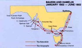
A map showing part of the Baudin explorations on the
south and east coast of New Holland (from Jacob and
Vellios, 1987)
Though the charts of the d’Entrecasteaux expedition had
yet to be published, Baudin was provided with preliminary
engravings. The enterprise was also mightily hampered by
having a microcosm of a fractured French society and in
having many civilian scientists on board.
Though many left the expedition in Mauritius, and returned
home intent on poisoning Baudin’s reputation, the
explorations, which were conducted between 1801 through
to 1803 resulted in many useful discoveries and
anthropological observations, in important chart and map
making, and in securing a vast number of natural science
specimens. Despite these successes, it has taken a full
two hundred years for Baudin to be favourably reassessed.
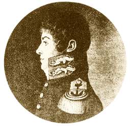
.Louis de
Freycinet and the de Vlamingh plate
On board Le Naturaliste was Sub-Lt Louis Freycinet.
While the ship was at Shark Bay he was sent by boat
to conduct surveys of the area—work that he later
continued while in command of Le Casuarina and later
in L’Uranie.
He also appears to have been on board when the ship’s chief
helmsman returned with an ancient inscribed pewter plate
commemorating the landing of the Dutch explorer Willem de
Vlamingh at Shark Bay in 1697. Having long-since fallen from its
post, it had been accidently found lying half buried in the sand
at the top of a prominent point overlooking the entrance to the
bay
 .
.
The discovery was of great historical significance, for on finding
a similar plate deposited by Dirk Hartog in 1616, Vlamingh had
the original inscription copied onto a new plate to which he
appended an account of his own visit before erecting it at the
same spot (Playford, 1998). He then sailed away with the
original, beginning a chain of events that was later to include
the visit of L’Uranie. Though the Naturaliste men found the
Vlamingh plate lying in the sand, where it had fallen from the
post, they recognised its importance and immediately brought
it back for Hamelin to examine.
In objecting to the notion that the plate be removed to France,
and in considering that to do otherwise would have been
historical ‘vandalism’ (Marchant, 1998:176; Halls, 1974),
Hamelin had Vlamingh’s plate and a plate of his own re-erected
on new posts, the first at the Dutch explorer’s site and the
second at an as yet undetermined location.
Freycinet apparently did not approve of this precursor to modern
museological thinking, and felt that it should have been removed
for safekeeping in France, but was too junior to prevent the
return of the relic to its original site. In recognising the importance
of the site, Freycinet’s chart of the region refers to the site as
Cap de L’Inscription (Cape Inscription).
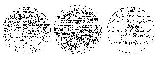
As unequivocal evidence of the prior landing of Europeans on
their shores, the Hartog, Vlamingh and the Hamelin plates are
relics of immense significance to Australians generally, and it
has been said by one historian that:
The
title deeds, so to speak, attesting European discovery of Western
Australia are three pewter plates left at Cape Inscription, Shark Bay,
on three separate occasion (Halls, 1974). L to R; Hartog
1616,
de Vlamingh 1697 and Hamelin 1803.
Go
to the Uranie voyages