
The Roebuck relics
The reasons for believing that the materials identified were
an indicator of the final resting place of HM Ship Roebuck
were thus:
1) The location of the bell in such a diverse wreckage field
while inconclusive, was a clear pointer to the loss of a
significant early vessel in the bay.
2) The location of the concreted grapnel near the shore
and in such a configuration as to indicate that its rope
was once tangled and that it was irretrievable when
abandoned, was considered highly significant.
The Captain’s Log of HMS Hastings for 5 April 1701 reads
as follows:
Satterday
5. . . Wind and Weath[er] Do [ditto]. In y
afternoon came on board seven Of y Roebuck men
at 10 at night got on board y Roebuck anchor being
her small bower and fourtenn fath[om] of cable
n giting of which o[ur] Longboat Lost her Grapnel
3) Cr Les Moss, the President of the Shire of Shark Bay,
and Hugh Edwards, noted wreck diver and author of a
recently-published book on the bay, both considered
that the clam was very similar to those found on the
north west coast of Western Australia and in nearby
tropical waters.
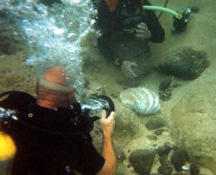
Geoff Kimpton
and the author excavating the clam
As there were no others seen throughout the inspection
and on the familiarisation dives conducted earlier,
it was considered to have been brought to the island
by human hand, most likely from the Indo-Pacific region.
When Dampier’s accounts of his collecting shells while
on the Australian coast were considered, the possibility
that it was part of his collection became evident. In his
account of events at Shark Bay that was published
subsequent to his return to England after the loss of
his ship, he wrote:
The
Shore was lined thick with many sorts of very
strange and beautiful Shells…. I brought away a
great many of them; but lost all except a very few,
and those not of the best
(Wm Dampier, Quoted in
the Wilkinson Edition, 1929:87).
Here Dampier refers to the loss of his ship and most
of his shell collection. If not a Shark Bay shell, possibly
it was one of the ‘cockles’ or clams varying upwards
from ‘10 pounds’ that were recovered from the waters
of Irian Jaya a short while before Roebuck turned back
for home.
If it could be confirmed as non-indigenous to Ascension
Island waters, and unless it could be proved that the
clam was introduced to the area by others e.g. by
American or British Service personnel or others
travelling from the Indo-Pacific region, here was a
clear indication that it was part of Dampier’s cargo.
On the balance, the bell, the clam, the grapnel, the
concreted ironwork and other debris, including the
ceramics in the rocks, were sufficient as an assemblage
o conclude that the team had possibly located the
wreck-site of HM Ship Roebuck.
The finds and these conclusions were reported that
afternoon to the Administrator HH Geoffrey Fairhurst
and the video record was shown to him, to Mrs Wendy
Fairhurst, Museum Curator, and to other museum and
island officials.
After being advised by the author that the exposed
objects were at risk and after faxing the British
Admiralty (owners of HM Ship Roebuck) of his thoughts,
Mr Fairhurst, as Island both Administrator and Receiver
of Wreck, requested that the objects be raised.
The movement of sand cover: a
fortuitous event.
In describing the extent to which rocks were visible on the
beach and underwater, we were advised that the sand
movement on the beach was unprecedented in HH
Fairhurst’s memory.
This was subsequently confirmed in discussions with
Mr Jimmy Young, a St Helenan, who after 40 years in
residence, since 1960, is the longest-serving resident
on Ascension Island. He indicated that he had never
seen the beach so eroded and that at one time it was
possible to walk in almost a direct line from the Turtle
Farm at the south end of the beach to the area now
occupied by the ‘Saints Beach Club’ barbecue hut at
the north end. That confirmed the understanding that
the remains were only recently uncovered.
Mr Young also advised of the removal of vast quantities
of sand for construction work during the Falklands conflict,
an activity that was halted by concerns over its effect on
the turtle population which regularly laid their eggs there.
Mr Young, who also dived with the 1985 RAF expedition,
indicated that they had tended to concentrate their searches
in the deeper waters around the island, being prevented by
the swell and their tow search methods from venturing in too
close. Finally Commander John Bingeman, leader of the 1979
search has advised that photographs of the beach taken
in the 1940s when the Americans were landing equipment
show the beach extending much further out to the west than
is the case today.
He has also recalls that the ‘Saints Beach Club’ was much
further back from the sea on the occasion of his visit in 1979
and that there was a ‘smooth incline’ from the beach down
to the sea and not the ‘sand cliff’ that the 2001 team
encountered.
The Ceramics
After the dive resulting in the recovery of the bell and clam,
Mr Young showed the Museum team ceramics that he had
recovered just a few weeks prior too their visit, when the
sand cover was even lower. Not thinking they were possibly
from the Roebuck, he did not report finding them earlier.
When he brought them to the attention of the museum team
and the Island Administration there was great excitement,
when the possibilities were realised!
Digital photographs and prints of the ceramics raised by Mr
Young and the Museum team were examined by Dr Christiaan
Jörg of the Groningen Museum, a specialist on 17th/18th
Century export wares for the Dutch market, and Dr Michael
Flecker, researcher and member of numerous expeditions
involving the recovery of similar ceramics. They were also
examined by my colleagues Rosemary Harper and Jeremy
Green, both involved in the examination of similar ceramics
from south-east Asia.
In respect of the jar, Dr Flecker’s comment read thus:
These jars are quite common. They have been found
on the
Witte Leeuw, which wrecked off Saint Helena in 1613, and on
the San Diego, which was lost off Fortune Island, south of
Manila, in 1600 [2]. I have also seen them at antique shop
s in the Philippines.
This type of jar seems to have been manufactured
for some
time with little change in form. Shipwreck evidence shows that
the form remained the same throughout the first half of the
17th century, and in all probability it changed little right through
to the 18th century. They were most probably produced at kilns
in Guangdong Province, southern China. The blue and white
ware provided much more information, being more easy to date.
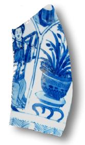
The blue-and-white jar lid and the shards are products of the
Jingdezhen kilns, Jiangxi Province, China.
The jar lid is very similar in form to hundreds of jar lids recovered
from the Vung Tau Wreck of c. 1690 [3]. The distinct panelled
decoration brings to mind kraak porcelain of the early 17th century,
although this technique carried on through the transition period
at the end of the Ming Dynasty and, in a less severe form, right
through the Kangxi period of the Qing Dynasty (1662-1722). …
While your lid is nowhere near imperial quality, it is of fairly high
export quality.
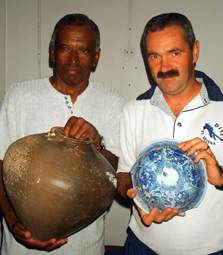
Mr Jimmy
Young and Flt Lt Richard Burke examine the
ceramics.
There is a possibility that the two shards are slightly later. While
Green and Harper concurred with Flecker, Dr Jörg felt that,
though it was not of imperial standard, the blue and white
ware was of high quality indeed, the sort of materials that
officers would acquire. All agreed that Batavia (now present-day
Jakarta) was most likely source of the ceramics, an important
observation as Roebuck spent a considerable time there effecting
repairs for the voyage home. Dr Jörg’s comments on the ceramics
and the female figures appear below.
The ladies in a garden setting are quite common
motifs in
this period. They are the so-called "Long Elizas", the long
slender ladies, in Dutch "Lange Lijzen" which became
Eliza's in English translation later. They walk in a garden
with flowering trees, banana trees, large rocks with many
holes specially collected for garden architecture and often
you see a small dancing boy, in Dutch traditionally called
a "zotje" (a fool).
It is a standard motif, and on these pieces executed with
great care and nice detail. It was certainly good quality
stuff, not just the ordinary run-of -the-mill object and can
be regarded, I think, as a personal belonging of someone
like Dampier himself, or one of the ship's officers.
The clam
The clam, which was found lying on its face inshore of the ceramics in
a turbulent location, had a heavily eroded back.
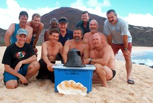
The Ascension Island and Museum team with the Bell and Clam.
While clearly Indo-Pacific in appearance, and similar to those found near
Shark Bay and further north, expert comment on its provenance and the
possibility that it was native to the Island was obtained from Ms Shirley
Slack-Smith and Dr Paddy Berry of the Western Australian Museum’s
Division of Natural Sciences. Ms Slack-Smith stated that:
From that character and from its general shape
and size, I can say that it belongs to the genus Tridacna and possibly
to the species Tridacna squamosa Lamarck, 1819.
Therefore I can be certain that the shell would have been collected (by
whoever) in the Indian Ocean or in the western part of the Pacific Ocean.
The genus Tridacna has a distributional range within the tropical and
sub-tropical waters of the Indo-West Pacific Region as far south as about
Shark Bay and southern Queensland in mainland Australia, northern South
Africa, and Lord Howe I and Pitcairn I in the Pacific. Northwards the
genus extends up the E coast of Africa and reaches the north of the Red
Sea, south and south-east Asia and Southern Japan. To the east, its range
extends to the Line Islands, the Marquesas and Pitcairn.If the clam is
of the species T. squamosa then it would have originated within a more
circumscribed area. This probably doesn't extend southwards beyond the
Ningaloo Reef and the southern groups of the G B Reef in Australia, Mozambique
in the west, halfway up the Red Sea, southern India, the SE of SE Asia
and southern
Japan
in the north, and eastwards only as far as the Marshall Is, Samoa and
Tonga. These limits may be a little out of date but the pattern would
hold good. So, the shell did not come
from the Atlantic, for sure.
As indicated in the account of the Roebuck voyage reproduced earlier,
there is no doubt that clams and other shells were on board and that many
were lost when the ship was wrecked at Ascension Island. Dampier recorded
the loss of the shells thus, for example:
I brought away a great many of them; but lost all except a very few, and
those not of the best’ (Wm Dampier, voyage to New
Holland, Reproduced in Wilkinson Edition, 1906: 87).
It is also known that Dampier collected shells at Shark Bay and LaGrange
Bay on the Australian coast. When in the vicinity of the north-west end
of New Guinea (Irian Jaya) not far from what is now known as Selat Dampier
the crew also recovered a variety of ‘cockles’, which from their
description are clearly clams, varying from 10 pounds through to 258 pounds
weight
There is little doubt then that this particular shell is part of Dampier’s
lost collection.
The
Bell
Firstly, and most importantly, of the vessels expected to have carried
a bell with a broad arrow, only HM Ship Roebuck is known to have been
lost in the vicinity of North West (Clarence Bay) on Ascension Island.
Secondly, and as expected, a comparison of archaeological and other data
indicates that the lesser importance given to a Royal Navy vessel, the
more spartan were its decorations and fittings.
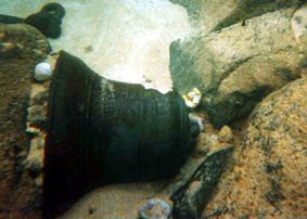
The Bell as found. Note the lack of weed on the
surrounding rocks.
In respect of the sort of vessel indicated by the Ascension Island find,
reference is made to the bell of the contemporary ‘fifth rate’
Dartmouth wrecked off Mull in 1690. It was 394 mm in height and it carried
the broad arrow or ‘pheon’ and the inscription DH 1678. As indicated
above, this 266-ton vessel, which was constructed in 1655 underwent a
major overhaul in 1678 when the bell was fitted.
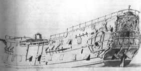
HM Ship 'Dartmouth'. The Broad
Arrow on its bell
appears on the previous page.
Further pertinent comparisons can be made with the bells recovered by
the Thanet Archaeological Unit from HM ship Stirling Castle (1703) and
possibly the Northumberland (1703) wrecks on the Goodwin Sands. Brought
to the author’s attention as this report was in its penultimate stage,
these two bells carried the date 1701, while that of the Stirling Castle
also bore the broad arrow
.
The unadorned Clarence Bay bell (300 mm high by 340 mm wide) with a broad
arrow, but with no other inscriptions, indicates that a Royal Navy vessel
of lesser import than HM ship Dartmouth was lost in the vicinity of the
find in Clarence Bay. (See discussion on Roebuck as a 5th or 6th Rate
ship above). Of importance are the similarities in the form and size of
the broad arrows on each bell.
The wreck site of HM Ship Roebuck
CONCLUSION
It is evident that the first anchoring place of Wm Dampier’s HM ship
Roebuck was close to or at the present tanker mooring just off Long Beach
in Clarence Bay, Ascension Island. No other place on the island fits the
bearings and descriptions given by Dampier. His rescuers all anchored
in a location not far from that same spot.
Dampier’s record of having run his vessel in with what appears to
have been a short-lived sea-breeze and his having anchored in 7 fathoms
before sending a small anchor ashore, allowing him to warp in fasten the
ship after it grounded in three and a half fathoms of water a cable’s
length from shore, would place the initial grounding point of his stricken
vessel on or against the line of submerged rocks lying c. 200 metres offshore
in North West Bay. These rise 1-1.5 metres off the seabed lying in that
same three and a half fathoms or c. 6-7 metres (21-24 feet) of water and
they would have prevented the waterlogged ship being warped in any further.
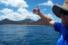
Hugh Edwards indicating the route Dampier took
to shore.
While John Penton’s evidence at the court martial (See Appendix 2
following) shows that Roebuck was ‘full up to ye hatches with water’
when it grounded, Charles Harbree’s use of the words ‘having
gott wthn a cables length of ye shore in sum short time after ye ship
sunk’ at the same hearing indicates that the grounding and the sinking
as the water flowed over the coamings into the ship were two separate
events.
Robert Sexton’s advice to the author that if one adds the c12-14
foot depth distance from the bottom of the keel to the lower deck to the
c.5-6 feet distance from there up to the next layer of plank on the upper
deck with the lip of the hatch comings a foot or so atop, then a distance
of 21 feet from keel to the top of the hatch coaming is realistic.
This provides some indication that Roebuck lay on top of the rocks a cables
length from shore and a short while after, apparently when the hull was
pierced by the rocks, it settled down onto the seabed a metre or so below.
This also indicates why it is not necessary to further consider the possibility
that Roebuck drifted back out so sea after it was abandoned, despite the
fact that the cable holding it eventually parted, or was cut as described
above.
The ship Hall being ‘dashed to 10,000 pieces’ in the swells
on the same beach in the August of 1834, provides a useful clue why Roebuck
was not seen by the rescuers and this could also provide some clue why
the cable would have parted as the stricken ship ‘worked’ back
and forth in the swells before totally breaking up.
The unadorned bell with a broad arrow indicates that a substantial, yet
not a major, Royal Navy vessel was lost in the vicinity or to seaward
of the find. Of all those service vessels lost on or near the island,
only William Dampier’s vessel HM Ship Roebuck is known to have been
grounded and abandoned in Clarence Bay, and from all deductions this occurred
a short distance south and west of the bell find.
Mr Young’s late 17th century Chinese ceramic finds, his report of
timber, the other grapnels, assorted wreckage, fastenings, other ceramics,
the chain plate, and the Indo-Pacific clam in shallow water inshore (east)
of the last calculated position for William Dampier’s ship Roebuck
are all consistent with materials expected from that vessel.
The rolling of the clam soon after it was freed from the rocks to which
it was attached, even in the moderate swells experienced by the Museum
team, attests to the strength of the seas, even on good days, and to the
ability of materials, even those as heavy and compact as a clamshell,
to move inshore from a location to seaward.
It is concluded on the basis of this evidence that the assemblage emanates
from HM Ship Roebuck and that the main portion of the wreck lies under
the sand, abeam the bell which lay to the north and west and slightly
to seaward of the other finds reported above that are located inshore
and to the east. The area containing the large grapnel is considered the
most likely place, and there is a distinct possibility that it lies on
what remains of the wreckage mound, which will include the iron ballast
that Dampier records loading into Roebuck before it departed England.
Some of Dampier’s shell collection, including the 258 pound specimen
recovered near what is now Selat Dampier off north-west Irian Jaya, may
also lie nearby.
Having agreed with both the Admiralty and the Island Administrator to
perform a non-disturbance study only, this conclusion was not tested Initially,
the Dampier materials were stored in an on-site facility on Ascension
Island until a decision was made on their conservation. Hearing of the
finds, Mr Charles Barker, Managing Director of the Mary Rose Archaeological
Services Ltd of Portsmouth offered to conduct the work and by consensus
of the Island Administration and the Museum team it was agreed that the
objects be sent there for treatment by Conservation Scientist, Ms Sue
Bickerton and Head Of Collections.
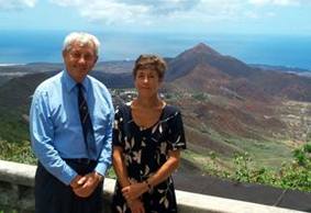
HH
Geoffrey Fairhurst, the Administrator, and Mrs Wendy
Fairhurst on Green Mountain.
Go to the Ascension
Island site
Go to Aftermath!