View Species
Peronella lesueuri
Authority: (Valenciennes, 1841)
Family: Laganidae
Peronella lesueuri was found at:
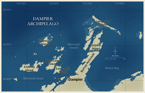
Distribution by Station:
- DA1/98/20 — E side of Collier Rocks
- DA2/99/01 — Mermaid Sound, N of Phillip Point, Burrup Peninsula
- DA2/99/04 — N-NW of Cohen Island
- DA2/99/18 — SE of Sloping Point, Burrup Peninsula
- DA2/99/29 — W of Cape Bruguieres
- DA2/99/32 — NE of Courtenay Head Light, Malus Island
- DA2/99/35 — W of High Point, on island NE of West Lewis Island
- DA2/99/37 — W-NW of Marks Point, West Lewis Island
- DA2/99/39 — E-NE of Bluff Point, Enderby Island
- DA2/99/40 — W-SW of Bluff Point, Enderby Island
- DA2/99/41 — N of Rocky Head, Enderby Island
- DA2/99/47 — W of Rocky Head, Enderby Island
- DA2/99/49 — W of the W point of Eaglehawk Island
- DA2/99/53 — W-NW point of Goodwyn Island
- DA2/99/60 — E-SE of Courtenay Head Light, Malus Island
- DA2/99/69 — SE of the SE point of Goodwyn Island
- DA2/99/71 — S of Rocky Head, Enderby Island
- DA2/99/72 — S-SW of Rocky Head, Enderby Island
- DA2/99/75 — E of the NE point of Goodwyn Island
- DA2/99/95 — W of Bluff Point, Enderby Island
- DA3/99/41 — S of Norbill Bay, NE of Georgeff Reefs
Documents
- Echinoderms of the Dampier Archipelago, Western Australia
Loisette M. Marsh and Susan M. Morrison
Search Options
![]()
![]()
![]()