View Species
Circe scripta
Authority: (Linnaeus, 1758)
Family: Veneridae
Circe scripta was found at:
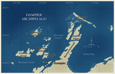
Distribution by Station:
- DA1/98/01 — E side of the N tip of Dolphin Island
- DA1/98/11 — W coast of S part of Dolphin Island
- DA1/98/20 — E side of Collier Rocks
- DA1/98/30 — E end of Sea Ripple Passage, near Sloping Point
- DA1/98/31 — Island towards E end of Sea Ripple Passage
- DA2/99/24 — N of Lady Nora Island
- DA2/99/35 — W of High Point, on island NE of West Lewis Island
- DA2/99/38 — W-SW of Marks Point, West Lewis Island
- DA2/99/39 — E-NE of Bluff Point, Enderby Island
- DA2/99/56 — W of Roly Rock
- DA2/99/60 — E-SE of Courtenay Head Light, Malus Island
- DA2/99/66 — E-SE of Bluff Point, Enderby Island
- DA2/99/67 — S-SE of Bluff Point, Enderby Island
- DA2/99/68 — S of Bluff Point, Enderby Island
- DA2/99/69 — SE of the SE point of Goodwyn Island
- DA2/99/70 — S-SW of Bluff Point, Enderby Island
- DA2/99/73 — S of Rocky Head, Enderby Island
- DA2/99/74 — SE of Rocky Head, Enderby Island
- DA2/99/94 — SE of King Point, East Lewis Island
- DA2/99/98 — S-SW of Bluff Point, Enderby Island
- DA3/99/54 — S side of large bay on the E coast of Enderby Island
- DA3/99/55 — Channel between Enderby Island and West Lewis Island
- DA3/99/56 — N of NW point of Eaglehawk Island
- DA3/99/67 — N of Nelson Rocks
Documents
- Diversity and distribution of subtidal benthic molluscs from the Dampier Archipelago, Western Australia; results of the 1999 dredge survey (DA2/99)
John D. Taylor and Emily A. Glover - A survey of the benthic molluscs of the Dampier Archipelago, Western Australia
Shirley M. Slack-Smith and Clay W. Bryce - Distribution, abundance and foraminiferal diet of an intertidal scaphopod, Laevidentalium lubricatum, around the Burrup Peninsula, Dampier, Western Australia
Emily Glover, John Taylor and John Whittaker
Search Options
![]()
![]()
![]()