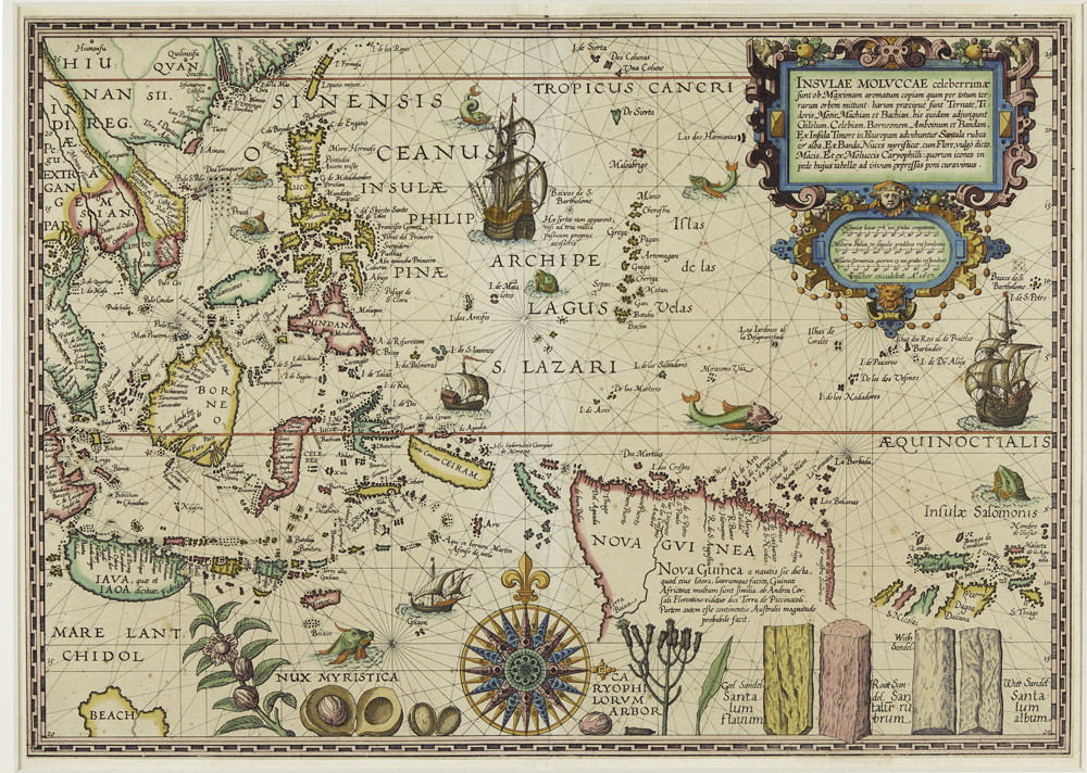
Stop 14 - Spice Map
Spice Map Plancius 1617, Kerry Stokes Collection 2014.086
This map made by Petrus Plancius (1552-1622 ) depicts the so called Spice Islands in the Indian Ocean (Moluccas) which today belong to Indonesia. In the lower left hand corner, below the island of Java, a small coast called “Beach” is a reference to the hypothetical southern continent - Australia - which had not been actually visited by Europeans at that time.
Plancius must have had strong feelings about this map when he made it around 1593. It was kept top secret - like many maps at that time - for political reasons until 1617 when it was published. This map is based on earlier cartography of the Portuguese and Spanish – the arch rivals of the Dutch who had monopolised the lucrative spice trade. Plancius had very personal reasons to support the young Dutch Republic against the Spanish in their competition over access to resources like spices in the Indian Ocean: he was a Calvinist who had to flee his home city Brussels when the Catholic Spanish occupied it in 1585 and this remained a bitter memory for him. Plancius had also very vested personal interests in producing the best possible maps for a successful Dutch journey to the Spice Islands because in 1602 he became a founding member of the Dutch East India Company.
This map does not reflect an innocent curiosity the Indian Ocean and its inhabitants which at the time were still largely unknown to Europeans. Instead the map is an expression of strong Dutch anticipation of obtaining very high profits which the spice trade yielded at that time because the Bandan Islands were the only place in the world where nutmeg trees grew.
The source of this unimaginable profit in the early modern period is depicted with botanical precision at the bottom of the map: clove, sandalwood (from Timor), nutmeg and mace which is the outer red husk around the shell of the nutmeg.
European maps in the early modern period were political weapons because their ownership could decide who won the race to access highly desired and profitable products - such as spices - which could only be obtained in the East. Secrecy was imperative and it is possible that the original map was carried by the captain of the Mauritius which sailed to the Spice Islands in 1597 in order to defeat the Spanish and which is depicted as a silver spice box in this exhibition.